
For weeks before starting the trail, I had been hearing about the dreaded Southern California San Jacinto Mountains with its tricky ice hiding behind Apache Peak and the long grueling slope of snow across Fuller Ridge. Everything I had read convinced me to send my shiny new micro spikes and ice axe to the town of Idyllwild so I’d be ready for the worst.

About a week into my hike, I was climbing up a ridge above Mt. Laguna and suddenly stopped, dumbfounded, staring at the white snowy peaks ahead. They looked so far away then, sparkling off in the distance. I could hardly believe that that snowy and scary challenge was less than two weeks away.
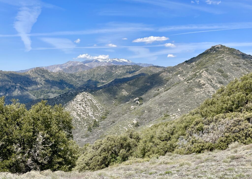
Ten days later, I was grinding up a hot and exposed moraine knowing that the top, named Lion Peak, was going to give me a view of the mountains and ridge line to come. And there they were, the multitude of peaks huddling around their namesake, San Jacinto, now considerably closer and larger; a vision of snow accompanied by a biting wind. It was all getting very real.

The San Jacintos are a force to reckon with; a large almost 11,000 foot mountain range which slashes north to south dividing arid Palm Springs and Joshua Tree National Park on the east from the cool ponderosa pine and cedar forests around the mountain towns of Riverside County to the west. The PCT mostly follows a 50ish-mile stretch along the ridge of this mountain range.

From Palm Springs, the San Jacintos tower above and are accessed by a fancy tramway up the cliff. Self-respecting PCT hikers don’t take this access, as there are about five other access points down the west side to the town of Idyllwild. It was one of these trails which I took down off the ridge to claim my first boxes at the post office containing my snow equipment and some yummies I had packed at home.

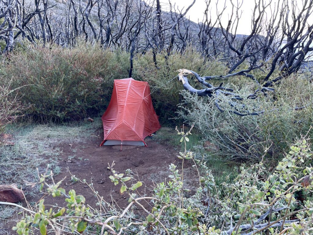
Two days later, the biting wind had turned into a gale but I was determined to head back up the ridge and deal with whatever would come. About three hours from the trailhead, I found myself crossing over the dreaded Apache Peak completely enshrouded in fog and hiking only by GPS navigation as I could barely see the trail. The mist was icy and the wind nearly knocked me off my feet. I was getting cold fast.
In another two miles, I found a little campsite, nestled my tent into the protection of some bushes, literally tying my rainfly to them, and dived in to get warm and dry. It was 1:00 in the afternoon.
On our PCT app, many hikers had written explanations of the extent of blowdowns in this fire-riddled area and they weren’t exaggerating… over, under, around huge tree trunks laid out like matchsticks for many tedious hours of the day.

Finally, I emerged from the tangle to a large open campsite- a great place to dry out my tent and sleeping bag from the drama of the night before.

Up to this point, I hadn’t seen another soul all day and while I sat in the sun eating my couscous lunch, another hiker named Antony from England appeared. We agreed to tackle the next challenge together – the snow!

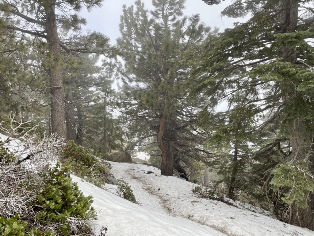
The trail immediately turned into the north side of a mountain where a crisp snow-covered forest awaited. It was fun to try out my spikes for the first time and since the snow was still crusty, traveling was easy. We finally were making some miles for the day.


We camped in snow that night, each in our separate tents. I forgot to tuck my wet socks into my bag to be warmed by my body heat and I woke to frozen wool cardboards… another day, another lesson. This is why PCT hikers pin their socks to the back of their pack drying them out in the morning sun.
Cold as it was at sunrise, Antony and I headed out into the crunchy white soon after dawn. It was so beautiful, winding through the huge pine and fir trees and looking down on the valley below. The morning held so much promise, for this was the day I was going to cross the final challenge of the San Jacintos: Fuller Ridge.

After awhile, we came down in elevation and were traversing a south side slope so snow patches were rare and we agreed to take off our spikes. A few minutes later, another snow patch appeared. Crossing it seemed like an innocent thing to do… until the final step. The morning ice was too slick for my trail runners and my ankle crumpled under my weight. Down I went with a howl… worrying that this split-second decision might end my grand adventure.
I wanted to scream and cry at the unfairness of it all, but instead, my practical side kicked into action.
Inside a couple of minutes, I had packed my already bulbous ankle in snow and was contemplating what was next. Obviously, I wouldn’t be traversing Fuller Ridge. I needed to go back down to town.
Antony helped me splint my ankle with my poop-hole shovel and tie it off with my Lycra tights. I swallowed a bunch of ibuprofen and he sent me hobbling the 4.5 miles down to a road. It took a long time to self-evacuate, and it certainly didn’t help my condition, but I already had befriended a local who I knew would help and the PCT mobile physical therapist was in town too. It was the best decision I could make.

So, here I am back in Idyllwild AGAIN. It seems like this town has a vortex making it difficult to leave. But the local trail PT gave me encouraging news and figures I’ll be back out slashing some miles soon. In the meantime, I have to be patient, slowly healing with some exercises, and acupuncture, hoping and dreaming of trail days to come.
Update: After some incredible kindness and support from the local Trail Angel community (who provided me free housing, wonderful meals and countless rides to therapy appointments), then sessions with Morgan with Blaze Physio and Keely at Idyllwild Community Acupuncture, my ankle is back in action and I’m heading out on trail again!


Tracey
God damn! You are a beast. Way to go tackling your first set back!
Andrea Scharf
Yow, Becky!!!! I feel like i’m right there with you (but without suffering the pain!!) You are such a trooper! But it sure it beautiful and i know you are loving this journey!!!
Andrea
Stephanie Morrison
Go, girl! Glad to hear you’re on the mend!
Gretchen Vos
Wow! That was a quick heal! What a good lesson right! And whenever you take a break and there’s ice around, give that ankle some time off!? You Go Girl!
Dawn Fulps
What stamina you have Becky! You go girl!!
Susan Arthur
Sorry to hear of your painful sprain but glad you are up and at em so soon. Enjoying reading about your hike, pictures are great!