
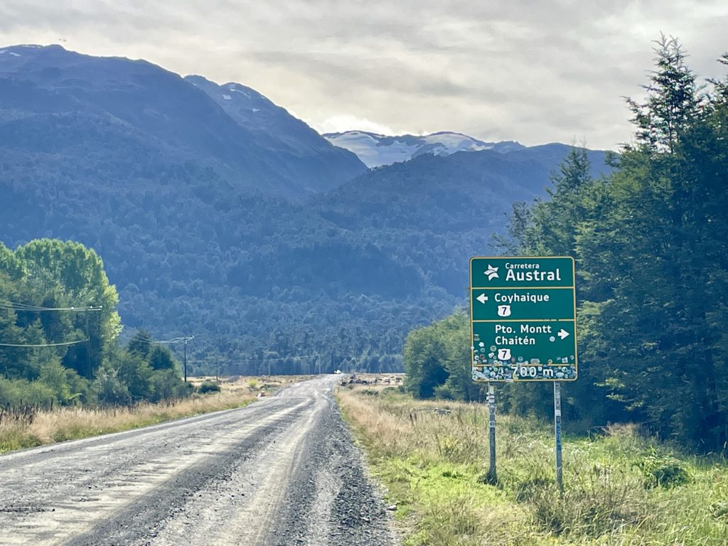
The Carretera Austral is considered one of the most beautiful roads in the world. Also known as Chile’s Ruta 7, it spans 1,257 km (775 miles) through incredible mountains, fjords and valleys between the cities of Puerto Montt and Villa O’Higgins. Although its span doesn’t seem that long on paper, this incredibly remote, rugged, rocky, pot-holed and sometimes paved road is something one needs to experience to fully understand. The route does connect a series of small towns supporting local ranchers and occasional visitors with necessary gas and snacks to travel on. But the real draw is between these urban centers, there are 11 National Parks and a multitude of Natural Reserves with endless opportunities for adventure in the great outdoors. Hiking, biking or driving the Carretera Austral (literally the “Southern Hemisphere Road”) is an adventure to be sure, and frankly, after spending three weeks along this stretch, I’m still having troubles processing all of its grand beauty.
When I first read about the Carretera Austral, I was in awe. I needed to travel this road, too! So, I quickly added it to my original plans for traveling north through Patagonia along the spine of the Andes. My planned route would have taken me via two ferryboats and a long overland hike to cross the border from Argentina into Chile where I would meet up with the road’s southern end. From there, I romanticized about hitchhiking up the length of the route, meeting locals as I went. It was going to to be great. But then, slowly, as my trip has progressed, my backpack has seemingly gotten heavier, the romance of hitchhiking has definitely faded, and my sore hip muscles made walking around the block difficult. How could I possibly do a multi-day hike over the border and be able to enjoy all the National Parks and adventures located along the route? I had to admit, my original plan needed to change.
So, I rerouted to a bigger city, spent three weeks during February in intensive physical therapy, and reconfigured a plan. To see all the Carretera Austral had to offer, It immediately became obvious that I needed a car. And since renting a car is expensive, I also needed a friend! I wondered, “Who do I know that would fly down to Chile on really short notice to take an expensive epic road trip with me?”
I wrote one text. She said yes!

My friend Brenda is the best adventure buddy anyone can imagine. Experienced in world travel, camping, hiking, and innumerable other adventure sports, she also drives a manual car- which, as it turned out, was extremely key in getting us through the pot-holed hell. She also says “Yes!” with a smile!
She’s my kind of friend!
In the beginning of March, Brenda and I met at the airport in Puerto Montt, Chile, picked up our rental car and headed to a big grocery store to stock up for three weeks worth of camping food and supplies. Dried soups, pastas, oatmeal, eggs, and tons of vegetables rounded out the Mountain House freeze dried meals Brenda generously brought along in her backpack. Since she had been cooped up in a plane seat during the night before, we started our trip by checking into a hostel and getting her a good night’s rest. Early the next morning, we headed out along a beautifully forested mountain road skirting a deep blue glacial fjord, and made it to our first ferry in Hornopiren by late afternoon.


The construction of the Carretera Austral started in 1976 under the dictatorship of Augusto Pinochet. His incentive was to connect a number of isolated fishing, mining and ranching communities which had sprung up during the 1950’s and 1960’s. Access to these villages had only previously been possible by boat and airplane. But in order to strengthen Chile’s presence in these remote regions, it was decided that a road should be built through this incredibly rugged landscape, equally famous for its extreme winter weather conditions. Over 10,000 soldiers were commissioned to build this road, and they finally were able to open the north half of the route from Puerto Montt to Coyhaique in 1988. By 1996, they completed another southern section and then, the final stretches down to Villa O’Higgins and out to Caleta Tortel were finished in 2000 and 2003. Whew!
Now, I wish they’d grade it! Some sections (with a small rental car) are almost impassable!
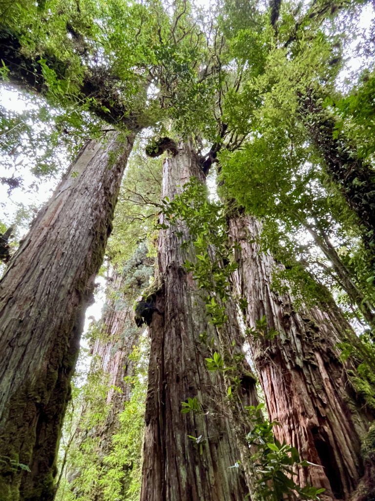
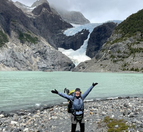
But I’m getting ahead of myself…. let’s start with the nice 5-hour ferry ride down the length of a beautiful glacial-carved fjord. Some parts of Chilean Patagonia are just too steep to build a road, so car ferries provide the connection in these stretches. There are essentially three different ferries to take the first day heading south out of Puerto Montt; a chance to sit back and enjoy the beautiful surroundings of Pumalín Douglas Tompkins National Park.


Douglas Tompkins, the founder of North Face and Esprit, decided to use his retail fortune to do some good for the environment in the places he loved: Chile and Argentina. He and his partner, Kristine McDivitt Tompkins, understood the importance of protecting the rich biodiversity of old-growth temperate rainforests, volcanos, glaciers, lakes, fjords and grasslands. So, in 1991, they started buying up thousands of hectares from ranchers and logging operations all over this area of Chile. Many in the communities along the Carretera Austral were suspicious of his intentions. However, in 2018, the Tompkins made the largest land donation to a government entity in the history of the world. They donated to Chile a total of 403,000 hectares (1500 square miles) across various land parcels for the purpose of vastly expanding the holdings of Chilean National Parks. Pumalín National Park was created because of their donation, and this temperate rainforest is magnificent, at least, from what we could see of it- because, well, it was raining most of the time we were there.
Pumalín Douglas Tompkins National Park


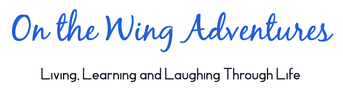
After a long evening of ferry rides, we landed in the Park around 11pm and headed to the first campsite we could find. We used our head lamps to set up our tents stake to stake with many other campers in a “community site”. The next day, we enjoyed a couple of short trails and got the chance to walk among some ancient Alerce Trees, a Patagonia Cypress. These trees live to be over a thousand years old and 25% of the remaining population in Chile are protected within the boundaries of this park.
That night it poured on us and we learned that Brenda’s tent wasn’t as waterproof as the previous owner had claimed. We needed to get out of the rain. Some of our campmates needed to get out of the park as well. So, we all piled in and headed south.
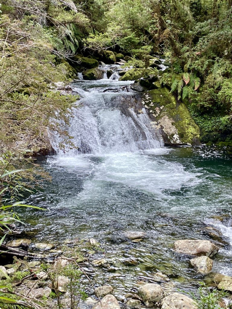
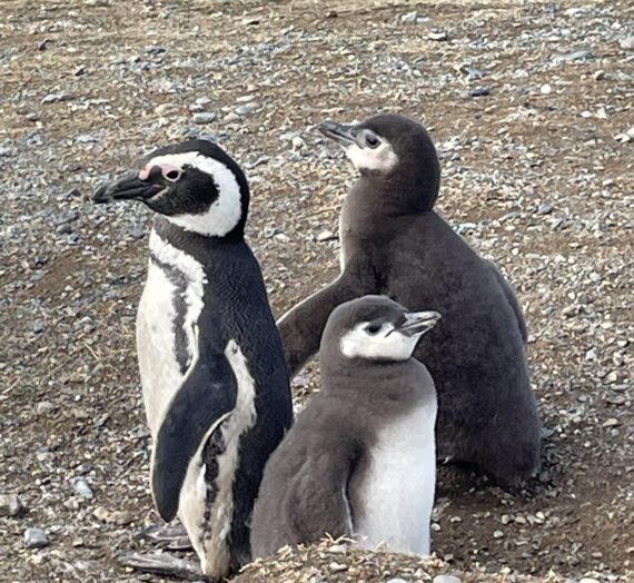
Early in our adventure, Brenda and I had decided we wanted to help every hitch-hiker that we could along our journey; after all, I was almost one of them. Hitchhiking is part of the culture down here and it is considered a safe and acceptable way of travel. But in these remote regions, there isn’t always a lot of traffic to help out these travelers. Some had been waiting for several hours and they were so thankful when we came along! During our first few days, we picked up quite a few Chilean students backpacking around in their final days before University classes started again. We also met a few guys from Israel celebrating their post-military service, a single woman from Germany, a kid from Norway, some locals just trying to get to the next town, and a couple from France who we ended up meeting again and again in the first days of our journey.


Faces of the Carreterra Austral; some of the hitch-hikers we helped out along the way.
Chaitén, the first town south of Puerto Montt
Chaitén is located strategically at the north end of the Carreterra Austral where you can access Pumalín National Park or even take an alternate ferry directly to Puerto Montt, skipping the park altogether. Chaitén also got put on the map in 2008 when a nearby volcano erupted, causing a catastrophic mudflow and flooding of the entire town. Much of the town has been cleaned up and reconstructed, but they’ve left some of the houses in place as a reminder of their recent history.


As it was raining, and being a Sunday (which means NOTHING is open in Chile), we scooted out of town for a drier place to hike and camp.
Corcovado National Park
This National Park was a surprise find for us. I had read that Corcovado was only accessible by boat, but just outside of Chaitén, we came upon this trail, mostly made of new boardwalk. This mostly flat trail led us through a lovely rainforest and up to Yelcho Glacier. It was a great outing in the waning light of day.


Camping along the Carretera Austral out of peak season was a little interesting. It was great that we weren’t fighting the summer crowds of January and February, but it also meant that some campgrounds were shut up tight. Quality also varied widely as some places didn’t offer showers or toilet paper for our $8-$12 per night, while others offered everything including a roof or a wind screen. We found all of our campgrounds by using the App on our phone called “IOverlander”. Since this app allows you to see your location live offline, it was a lifesaver for finding great trails and beautiful vistas as well!


In Chile, campgrounds are always marked along the highway with bright colored flags. Commonly, camping was offered in people’s farm lots, but more developed campgrounds had covered shelters for sleeping, cooking and eating. One family let us sleep on the floor of a camper’s kitchen. Another offered a dormitory for wet nights. We were happy for them all.
Onward to Futaleufú

Futaleufú (Foo-ta-lay-fu) is not exactly on the Carretera Austral, but it’s too good to pass up. Known for its beautiful mountain scenery and world-class white-water rafting on the profoundly turquoise river “Futa”, it was definitely a highlight of our trip.
The next morning, after drying out our tents in the warm breezes, we headed into town to buy tickets for a white-water rafting trip that afternoon. In the sunshine, this seemed like such a good idea!


By 3:00pm it was cold, foggy and pouring. We surmised that at least we were going to get wet anyway, but really, we had no idea what we were in for.
Futaleufú, as it was pointed out to us by our guide, is an Indigenous word meaning “big river” and after so many days of rain in the area, we were going to experience some really big waves. The guides and rescue team spent over 30-minutes explaining and demonstrating safety protocols in case someone fell out of a boat. I admit to being cold and impatient, thinking that I have white-water rafted before and it’s really not THAT big of a deal!
But the “Futa”, as we learned, is a very big deal.

After 90-minutes of hurtling through 13 different Class III, IV and V rapids, we were thoroughly impressed. Among the shouted commands from Pedro, our rafting guide, to paddle “forward” and “back”, there was another command for “knee” when we had to duck inside the boat because we were about to hit a literal wall of water. The guides estimated that on this day, the river was flowing at a high volume of 400 cubic meters of water every second. And from the time we started our trip, the river had grown 22 cm. Pedro was just overflowing with giddiness at the size of the water we were traversing. Of course, Brendra and I sitting in the front of the boat loved it all, too. Thank goodness the adventure came with a photographer to provide the proof of our wild ride!


The next day, the sun came out for a little while again, so we went back to the river to see its full splendor in the sun!


Then, we were on our way south again.

By evening, we made it as far as La Junta, to find a great backyard campground and fresh eggs from Sergio and his wife. The campsite also came with a sheltered kitchen, complete with a stove and pans. This was a novel idea for us, but since I had my own backpacking stove, I proceeded to start cooking dinner with it instead. Unfortunately, the 93-octane unleaded-fuel we were using chose that moment to clog up the mechanisms of my little stove. We suddenly understood the full benefit of covered “quinchos” or complete outdoor kitchens for travelers. While Brenda cooked for us in the provided kitchen, I pulled on my big-girl pants and set about cleaning the inner workings of my stove- not a job that I was looking forward to. I don’t think I’m very good at mechanical things. But I did it! I was so proud of myself when it all fit back together and started working again! To avoid this dirty problem in the future, I decided that we needed to find some white gas instead- which Chileans use as a cleaning fuel for their tools. Luckily, the next day, a local hardware store had some in stock and we never had a stove problem again!
By this time of the morning, the rain had set in again, and we learned that the nearby Queulat National Park, and the trail to an infamous hanging glacier, was only open for the morning hours. So, with our plan foiled, we hobbled past the town of Puyuhaupi and the park, (the road was a disaster) and hoped we’d be able to see more of them both during our return north in three weeks time.

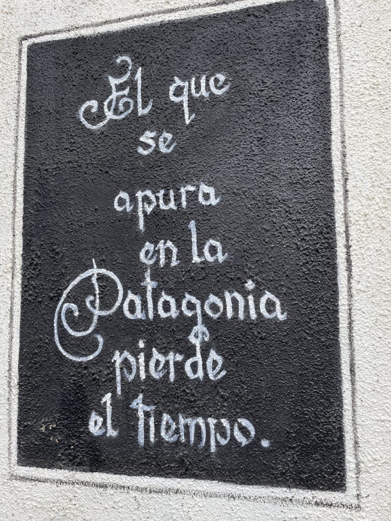

Throughout our adventure, we were reminded again and again of this popular adage:
“Those who rush in Patagonia, waste their time.”
For this big road-trip, Brenda had brought Curious George (or Jórge Curioso) to be our trusty mascot. He watched the road everyday from the dashboard. The constant barrage of yellow signs along this route warned us of falling rock, steep curves (where the road surface was actually painted red) and steep up or downhills. This last sign was especially useful for the road department because they could bolt it to the post at different angles depending on the seriousness of the grade.


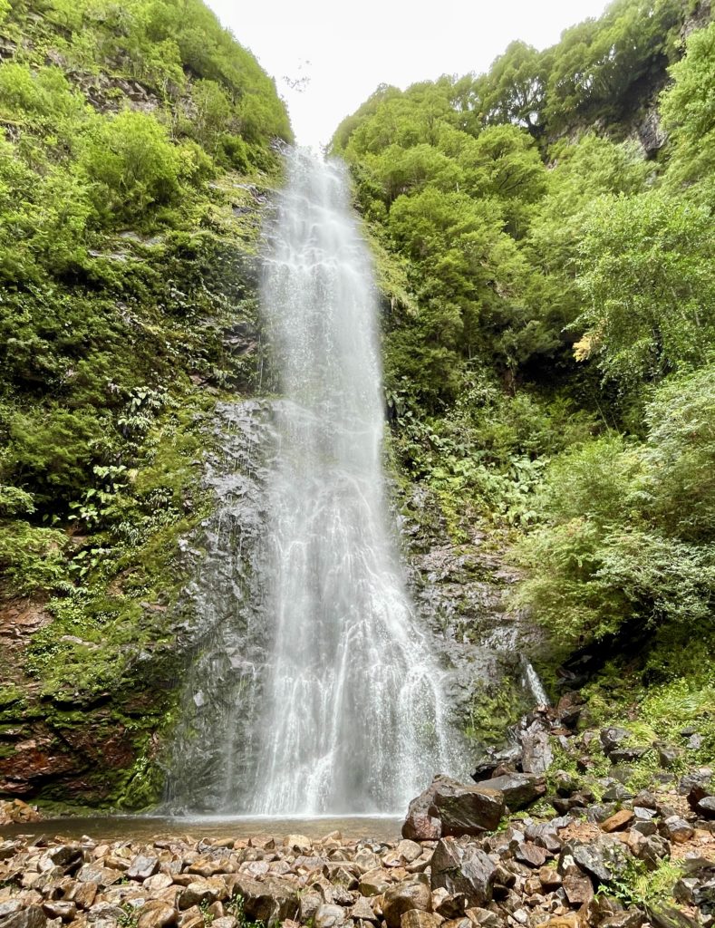
Just south of the park, however, we learned of another trail called Bosque Encantado. This is a closed, overgrown, unmaintained and landslide-riddled trail, that led to another spectacular hanging glacier and lake. We were warned that if we attempted this trail, our safety was our own responsibility. All of that scared us off for awhile and we had practically talked ourselves out of doing this trail, when our car paused at the trailhead long enough for us to see that our first obstacle would be a cabled river crossing. That sealed it. We were in! Two and half hours of creek sloshing, orienteering with my Maps.Me App, and climbing over and under massive trees in a huge landslide brought us to an enormous boulder field and the ultimate prize- a beautiful blue glacial lake in the mountains of Chile. Sometimes in life, you just shouldn’t follow all the rules!


The perfect adventure hike for us both!
Puerto Aysén
The next town on our route was a little out-of-the-way port city called Puerto Aysén. While researching my options of traveling the Carretera, I had considered bringing the ferry in or out of here, so I just had to see it for myself. Admittedly, it wasn’t much. But we did get to sleep in what we think was the old lean-to for a horse and we had our first restaurant fish dinner to celebrate. Onward to Coyhaique!

Coyhaique

Coyhaique (ko-I-k) is the largest city along the Carreterra Austral with over 60,000 people. It seemed like a metropolis with big-box stores and free museums about the history of the region. Brenda found an authentic Patagonia wool hat, bought some $12 duct tape for her tent, we got gas, and ice cream, and then found our way to a lovely lake region just outside of town.


Coyhaique is considered by many as a general “half-way” point along the Carretera Austral. Further south the road and the population peter out significantly. For me, the southern part of the road was where the mountains seemed more immense and the vast remoteness of this crazy adventure really set in.
Stay tuned for our Carretera Austral Adventure, Part 2. It just keeps getting better!
Gayle Warberg
Priceless adventures! You are incredibly brave ladies and making the most out of every opportunity! Gorgeous vistas! Carry on warriors!